Day 63: Challenge Accepted

Date: June 11, 2017
Miles: 775.2 – 787 

“We signed up for this.” ~ Shortcut

The last three days I’ve experienced some of the most difficult, exhilarating, and nerve-racking moments that I can remember having in a long while, with the summiting of Mt. Whitney (the tallest mountain in the lower 48), fording the rapids of White Creek, miles of snow travel, and today’s crossing of Forester Pass, which is the highest point on the PCT at 13,200 feet. 

The Pass.

We left camp at 4 am and made our way across nearly 5 miles of frozen sun cups until we reached a point below the Pass at which we had to climb a steep wall of snow (the trail switchbacks were buried somewhere underneath) and then step our way across a ledge cut in to the cornice near the top of the pass. One misstep on the ledge could have meant a long slide down the icy chute. I was nervous for John since he lost one of his microspikes somewhere on the trail yesterday and so was climbing with just the one he had left. I was also nervous for myself since I have a healthy fear of heights. My legs were shaking pretty badly by the time I crossed to the other side and I couldn’t stop breathing hard for a few minutes. It was amazing. 

Matthew crossing the chute.

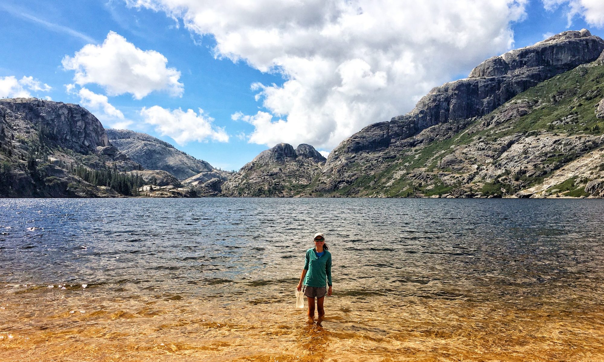
After the pass, we descended into Kings Canyon National Park and walked in between the Kearsarge Pinnacles and a raging Bubbs Creek. The sights of the walls of rock shooting up on either side of us and the water cascading rapidly over smooth slabs and waterfall chutes was what I pictured in my mind when I thought about going through the Sierras. The snow has added an exhausting element to that image…I would like to come back when the trail is clear so I can really experience this place without having to give it so much energy. 


We reached Vidette Meadow (more of a swamp at this time of year) and decided to stop and camp since we didn’t like the look of some gray clouds building to the west of us and we didn’t want to do the following 1000 foot climb and be stuck in a snowstorm. Connor got a fire going and we were able to dry out our shoes for the first time in days. The wind picked up and we all retreated to our tents at about 5:30 pm to escape the cold. I didn’t mind…it gave me a little time to myself to actually read a little before my sore body and falling eyelids decided it was time for sleep. 

Starting out.


A sunrise selfie.
l-r: Roi, Matthew, Connor, Katie, John, me.
A celebratory granola bar.

Heading down the other side.
Thank goodness for logs.

Blowdown and avalanche damage.
Finally! Camp!

Day 62: God Willing And The Creeks Don’t Rise

Date: June 10, 2017
Miles: Whitney Trail Mile .8 to 775.2 

“We’ve gone from melted snickers to frozen snickers. I don’t feel like there was ever an in-between.” ~ Strongback 

We slept in until 6 this morning to recover a bit from yesterday, then we packed up and headed out. The first ford of the day was Wallace Creek, which was cold! 

John, taking his turn.

This was where I learned that the Altra boots I had purchased in Lone Pine were, in addition to being the opposite of waterproof, actually really good at keeping water soaked in to the cushy lining of the boot no matter what I tried to get it out. Likewise, the neoprene socks I thought I’d try for post-water crossings were only waterproof for two seconds, but they did do a good job of keeping my feet warm in the wet boots. 

Matthew found out his shoes were crap after this as well.

Keeping with the Sierra theme, we spent more time hiking through more snow, and then group forded Wright creek, which was terrifying. I don’t have any pictures because we all went across in a line, linked arm in arm so no one would get swept away by the fast moving rapids. We all made it, the only casualty being John’s sunglasses. We caught our collective breath, dried out a bit and then slogged through a slush covered Bighorn Plateau until we hit Tyndall Creek. The creek was already a fast-moving river with walls of snow on either side, making it impossible to find good ingress and egress points for a while. We had to walk about a mile upriver until we found an intact snow bridge we could cross. From the looks of it and the upcoming heat wave, it won’t be there much longer.  


We camped on a dry patch of rocky ground just past the crossing and readied ourselves for the next day’s Forester Pass crossing by eating a lot and crashing. Should be exciting!


Snow baseball!

Miles and miles of this.


Trying to avoid the sun from all angles.

I feel like this tree was saying, ‘hey, so you guys are hiking the PCT, huh? Has anyone told you you’re gonna die out here?’

Pusheen is still truckin’…

Day 61: On Top Of The Lower 48

Date: June 9, 2017
Miles: Guitar Lake to summit of Mt. Whitney, then back to mile .8 on Mt. Whitney Trail. 

* Warning – there is one definitely NSFW pic in this post. But it’s funny. *

I slept horribly last night. I don’t know if it was the anticipation of the Mt. Whitney climb today or the elevation. I should have slept well…I was in the most comfortable, warm spot in my quilt and I was exhausted from yesterday’s hike. But I tossed and turned until 3 am, when I got up and got ready to leave camp at 4. Despite not sleeping, though, I felt good.


 The first couple hours of the hike was on consolidated snow under a full moon. 


The rest of the climb was a temperate grade, with some scrambling and a couple snow patches, up to a very windy summit at 14,505 feet.  


We stayed on the summit long enough for Roi and Connor to have their picture taken triumphantly au natural and then we quickly headed back down the mountain to get out of the constant wind. 

The girl sitting by the hut got more of a view than she expected today!

We had nap time at camp, then packed up and headed a few miles toward the PCT to camp near the creek by the Crabtree Meadow Ranger station.  


Katie finally got the trail name Shortcut because of her affinity for cutting switchbacks and for finding a more straightforward way of getting from point A to B. As we rehydrated our dinners, we talked about all of the high fat foods with which we could try to put some weight on our bones again…honey buns with butter on them came out as a clear favorite and we all swore we would fill our bear cans with those the next time we resupplied. Food is a frequent topic of conversation, especially this week when we’re all burning so many more calories and feeling hunger pangs most of the day. 

We all went to bed at 6:45 pm to the sound of a helicopter circling through the Meadow several times, hoping it was a training exercise and not a search and rescue.  (Note: We heard a few days later that the helicopter was there to pick up our friend Gummies who developed pulmonary edema from the altitude. He has since recovered, for which I am grateful. It’s also a good example of why hikers should carry locator beacons like the Spot or the InReach…it’s a good thing he did!) 


The summit of Mt. Whitney.


Day 60: Snow, Snow and More Snow

Date: June 8, 2017
Miles: 760.5 – 5 miles before Mt. Whitney on Mt. Whitney trail. 

This morning started with a big climb over Guyot Pass and…surprise…more snow! We unexpectedly found Orange, John and Gringo at the junction to Mt. Whitney and they hiked out with us from that point. I was excited to get to our first actual in-the-creek crossing at Whitney Creek, which ended up being bracingly cold but uneventful. 

We headed up the John Muir Trail to Guitar Lake in slushy snow. I slipped and slid all over the place, and was exhausted by the time we found a place to camp up the shore from the lake. 

Gringo let us know that he was leaving for Vegas and Orange said that he was going to spend a few days in Independence waiting for us to finish the next few days and join him there. At that point, I decided that I would take the next couple days to decide whether I’m going to finish the Sierras or skip ahead. It is beautiful out here in the snow, but I would love to be able to enjoy the scenery without constantly staring at my feet so I can stay upright through the suncups or sliding around in the slush.


At the end of the day, I found a sweet little ledge on which to set up my tent, and we all made plans to leave at 4 am the next morning for a Mt. Whitney summit.  Exciting!


Day 59: Sierra Blues

Date: June 7, 2017
Miles: 750.9 – 760.5 

I cowboy camped last night and when I woke up, my quilt was completely frosted over. I was toasty warm though, and it felt pretty awesome to think that I slept outside at 11,000 feet.  


We all packed up and headed back to the trail, working our way down mounds of snow, crossing into Sequoia National Park and passing through the Siberian Outpost to Rock Creek. We didn’t make much mileage, but it was tiring nonetheless. Not only is it physically draining to walk through snow all day, but it can be mentally tough for a hiker who is used to making 20-30 miles a day to suddenly be held to 10-15 miles. They’re like greyhounds being held at the race gate. 


I learned a new skill today…boot skiing. I’m pretty awful at it. Most of the time I end up on my ass.  I’m sure I’m going to get more practice than I can handle out here. 


We reached camp early in the day, but we didn’t want to go on because of the huge climb out of the creek with no campsites located within a reasonable distance. So I took some extra time to sit alone by the creek soaking up sun and thinking about home. I’ve been feeling lonely and homesick since Tim left and have had the thought that I could go home and still feel like I’ve accomplished something without finishing the trail.  I read some of my Pacific Crest Trials book to try to get a different perspective, and reviewed my list of reasons for doing this and that helped relieve my trail blues a little.  I went to bed feeling more optimistic and decided that I will give the trail one more week and see how I feel then. 


Day 58: Resupply Madness

Date: June 6, 2017
Miles: 744.51 – 750.95 

Resupply days can be so stressful. All hikers really want is to able to walk, eat and sleep…the simple, uncomplicated things. And we also want to stuff our faces with food when we get to towns. But a day in town usually means buying groceries, picking up packages, maybe buying new gear, doing laundry, getting clean, etc. Which is what we did today.  I ran errands all over Lone Pine, picked up food at the post office, bought a bunch of stuff at the gear shops, went to the grocery store, had breakfast and lunch at the all you can eat lunch buffet at the pizza place. 

Shiny new shoes. Spoiler alert: Altra says they’re waterproof. They’re not.

We quickly hitched a ride back to Horseshoe Meadows and headed up Cottonwood Pass to get back to the trail. We got a chance to use our crampons and ice axes for the last stretch. 

Our driver, Richard (I think?). All of his siblings in California and Washington like to help hikers.

Shiny, clean and ready to start sweating again!

We camped at the frozen Chicken Spring Lake, which is located in the Inyo National Forest and the Golden Trout Wilderness. A flock of birds entertained us with their never ending quest to find our crumbs. A really bold male romanced more than one of the ladies right at the feet of our sleeping bags, and on that note we all hit the hay. 

Setting up camp at Chicken Spring Lake.
The avian Casanova.

“Bear Cans at Sunset.”

Day 57: Buzzed In The Sierra

Date: June 5, 2017
Miles: 730.8 – 744.51 

We had a couple big hills to climb today but they weren’t as lung-busting as I thought they were going to be, and the reward at the top was an expansive view of Owens Valley. 

Matthew, Roi and I took a break to enjoy the view and to wait for Katie and Connor, and within a few minutes we were buzzed by a fighter jet that flew over our heads, tipped its wings in our direction and sped down the canyon in front of us into the valley. It was awesome! 


Our destination for the evening was Horseshoe Meadows campground, where we hoped to get a ride in to Lone Pine to resupply.  We were worried that we weren’t going to find many people there, but as soon as we walked in to the parking lot, a man asked us if we wanted a ride in to town. Lucky for us!  

How to fit six hikers and their packs in a compact car…

The first thing we did was head to McDonalds for a 50 piece box of chicken nuggets and cheeseburgers, and then we crammed six hikers into a room at the Dow Villa Hotel.  Tomorrow will be a busy and quick resupply day so we can work on getting a hitch back up to the campground and back on trail. 


Connor and Roi creating Titanic: the Sierras


Day 56: To New Heights

Date: June 4, 2017
Miles: 716.46 – 730.8 

We climbed from 7,833 feet to over 10,500 feet today, and with the heavy packs and thinner air, it was a struggle. The saving grace was that water was everywhere and I only had to carry a liter at any given time. That’s good, because water is freaking heavy. 


I took frequent breaks so I could take my pack off for a bit to keep my spine from telescoping.  I saw marmots for the first time and I really hoped that they would stand up and start screaming like this guy, but no such luck today. 

I swear this is a marmot. This is the best I could do.

We also reached snow!  Not for the first time on the trail, obviously, but for the first time in the Sierra section, which was exciting in an ‘oh my lord, I think this is the beginning of snowmageddon’ kind of way. 


The last bit of the day was spent descending down to 8,956 feet and then setting up camp by a lovely place called Death Canyon Creek.  I didn’t get a picture of it, but I promise that I t looked better than it sounds. 


Snowball fight!

Day 55: Monster Backpacks and Bigger Fears

Date: June 3, 2017
Miles: 704.6 – 716.46 

I was buzzing with anxiety today as I got ready to leave Kennedy Meadows and Tim. I had a monster backpack on my back, my big Salomon waterproof boots on my feet, and a multitude of Sierra fears in my brain.

That may appear to be a smile, but it’s a borderline grimace of pain.

Eventually, Katie, Connor, Roi, Matthew and I headed out. 

l-r: Roi, Matthew, Katie, Connor, and me.

The temperature was high and my feet were roasting in the big boots, so I stopped every chance I got to rest and soak my feet in cold water.  I became increasingly crabby with the weight and constant squeakiness of my Osprey pack…it felt as though a small man was bear hugging me and refusing to let go.  But I knew that the real source of my irritability was my intolerance of change and of being out of my comfort zone, so I resolved to work on those things as I walked and hoped for the best. 


At the end of the day, we camped with another hiker named High Risk in a neat little campground tucked away above the South fork of the Kern River and a bridge with swallows nests tucked underneath it.  


Connor and Katie went to take a swim in the river and I joined them for a bit, then I went to watch the birds zip in and out of their homes. As they all randomly let poo bombs fly into the river, I was reminded that I needed to filter water and then make some dinner before getting some sleep, so I did those things and then drifted off with a full belly and a still mind. 

My shiny new Z-lite sleeping pad and old 1,000,000 pound pack.


The Kern River.

Days 53 & 54: The Gateway to the Sierra

Date: June 1 & 2, 2017
Miles: 680.9 – 702.2

Today was the day we hit 700 miles and reached Kennedy Meadows, the start of the Sierra sections and the place where most everyone bulks up their packs with bear cans and snow gear and heads out into the mountainous wilderness.  But first, we had a welcome change of scenery with the trail following alongside the Kern River for a few miles. 

Tim was waiting for us at the road in to the Kennedy Meadows General Store (I am sure getting used to having my own trail angel) and he gave us a ride there to check it out and then to a campground a couple miles away. 

The next morning, we went back to the store but, not finding it open yet, we went down the road to Grumpy Bear’s to get the all-you-can-eat pancake breakfast. The pancakes were bigger than our heads. Matthew was stoked because he has an amazing capacity to eat large quantities of pancakes in one sitting. 


I had high expectations for KM, thinking that it would be abuzz with hiker excitement and full of good things to eat. In reality, it was underwhelming.  The surly store owners didn’t seem to like hikers much, even though we were forking over good money to retrieve our packages and to buy overpriced goods. 

The General Store.

So we decided to drive in to Lone Pine to do laundry and spend money. I sent myself WAY too much food and a lot of it won’t fit in the bear can, so I left some of it at the post office to pick up later. 

Too. Much. Food.

We headed back to the campground to stay one more night and get ready to head in to the Sierra the next morning.  I had a good bit of anxiety wondering what lies ahead in terms of snow and river crossings…we’ll see how it goes!

Some flat walking before the high elevations of the Sierra.

700 miles!


The pack is about to get a lot heavier. Ugh.

Connor models the hiker’s laundry chic. Rain gear.

My chauffeur, gear mule, emotional support, provider of laundry quarters and best friend. ❤️